MH370 Fuel Endurance - Could 9M-MRO have flown beyond 00:19 UTC?
- Details
- Written by Juanda Ismail
Endurance in aviation terms, is the time an aircraft can remain in the air given the amount of fuel carried when airborne. In the case of MH370, it became airborne from Kuala Lumpur International Airport (WMKK) at 16:42 UTC carrying 49,200 kg of fuel, and is widely thought to have crashed around 00:19 UTC. This gave MH370 an endurance of around 7 hours and 35 minutes*1, with an average fuel flow of 6,500 kg/hr.
1. Aim
The aim of this article is to investigate whether, hypothetically, MH370 (9M-MRO) with 49,200 kg of fuel onboard could fly beyond 00:19 UTC. Or to put it in another way, could the fuel MH370 had on departure last longer than 7 hours and 35 minutes?
This question can be best answered by referring to the document ‘Boeing Performance Analysis- Malaysian Airlines 777 9M-MRO 08 March 2014’, which is included in Safety Investigation Report, 2018 as appendix 1.6E.
2. Segment 1 to 5
In determining how far and how long MH370 could have theoretically flown, Boeing divided the flight in to 6 segments. Segments 1 to 5 are shown below, with my annotations in green for the estimated fuel remaining at the end of each segment. The fuel at the end of segment 5, which corresponds with the first Inmarsat ping, Arc 1, was 33,500 kg and is used as the starting point for determining MH370's endurance and range for the remainder of the flight.
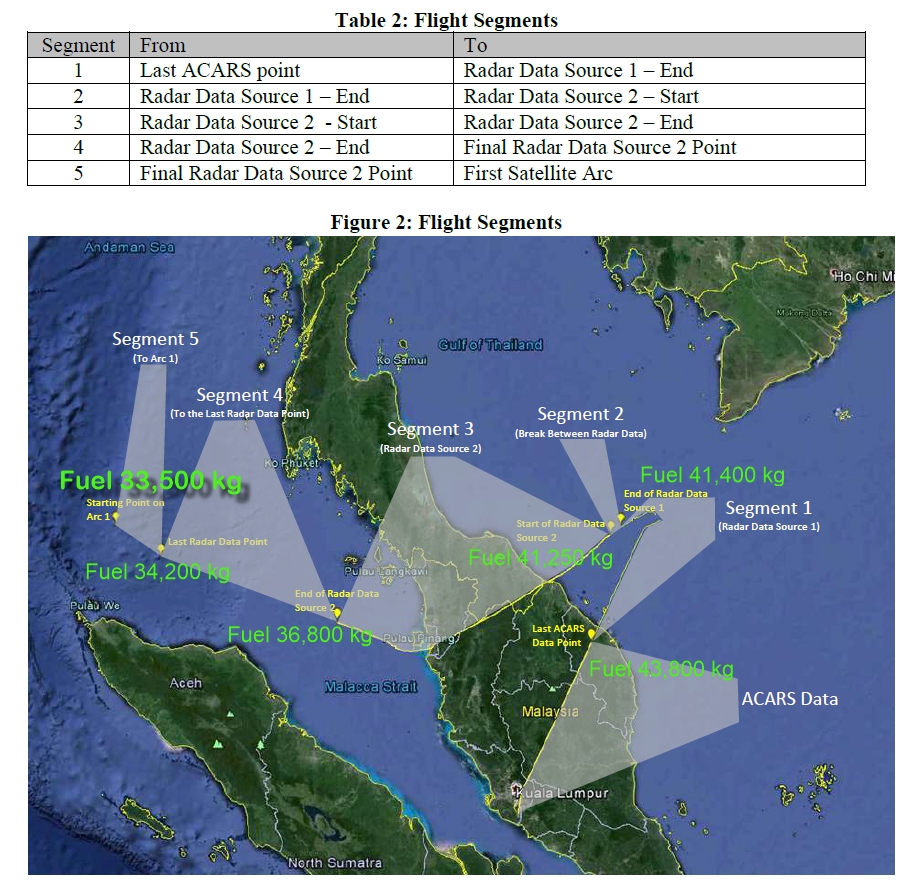
An estimate of the average fuel flow during the cruise phase of flight can be determined from the 17:07 ACARS position report, which corresponds with the start of segment 1. This showed MH370 had 43,800 kg at a cruising altitude of 35,000 ft. Between the start of segment 1 to the end of segment 5, MH370 han an estimated fuel burn of 10,300 kg over a time interval of 1 hour and 21 minutes, giving an average cruise fuel flow of 7,600 kg/hr.
3. The Final Segment
The final segment of the flight began at Arc 1 with 33,500 kg of fuel and ended when the aircraft exhausted all of this fuel. As the altitude and airspeed for this final segment were unknown, Boeing calculated a range of speeds between the minimum possible cruise speed to the maximum operating speed for 6 different flight levels, ranging from FL400 (40,000 ft) to FL030 (3000 ft). This is tabulated below in Table 4 showing the Range Capability for various altitude and airspeed combinations from Arc 1, to the end point at fuel exhaustion.
Of interest is the 'Time' column, as this indicates how long MH370 could have remained flying from 18:28 UTC until it ran out of fuel. The reason why there are a number of different possible end points is because an aircraft's fuel burn is affected by its cruising altitude*3 and engine thrust settings*4 amongst other factors.
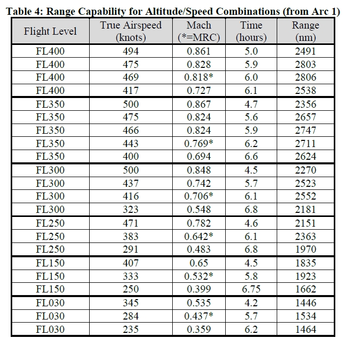
There is very good evidence to suggest that MH370 crashed very near to Arc 7. Since Arc 7 occurred at 00:19 UTC, which is 6 hours and 9 minutes after the Arc 1 time of 18:28 UTC, then the rows which includes ‘Time’ equalling as close to 6.1 to 6.2 hours are good candidates for where the end point for MH370 is.
Furthermore, any ‘Time’ value greater than 6.2 hours suggests that MH370 could have flown beyond 00:19 UTC with the fuel it had onboard on departure from Kuala Lumpur.
The highest value for ‘Time’ in table 4 above is 6.8 hours which corresponds to 6 hours and 48 minutes, giving an end of flight time of 01:16 UTC. This can occur when cruising at FL300 and FL250 with engine thrust settings giving true airspeeds of 323 knots and 291 knots (nautical miles per hour).
So, the answer to the aim of this article of whether MH370 had the fuel to fly beyond 00:19 UTC, is YES.
4. Why MH370 Has Not Been Found
Despite the calculations that Boeing have made, as well as other supporting scientific and mathematical analysis by other experts, two extensive searches for MH370 near Arc 7 have failed to find the aircraft. The reason for this may be attributed to not having enough information about MH370's actual flight characteristics beyond the last ACARS position report at 17:07 UTC. As a result, assumptions had to be made for the aircraft's flight to fuel exhaustion, such as the aircraft's cruising altitude, airspeeds and engine thrust settings, automatic pilot mode and even whether the flight was flown entirely on automatic pilot engaged or with it off.
If any of these assumptions were wrong, then there is a greater chance that the aircraft did not end up where the mathematics suggest it would. To quote Dr. Neil Gordon from the Defense Science and Technology Group, Australia, who's group was tasked with narrowing down the search area for MH370 through analyzing the satellite communications data, "The sort of difficulty we always come up with is, at the end of the day it’s a probability distribution, it’s not an analytic solution with a guarantee. It’s a distribution that represents the prioritized belief as to where you think it is relative to other places." *5
The assumptions that were made in coming up with the Arc 7 search area is a whole topic in itself and will be discussed in a separate forthcoming article.
Footnotes:
*1. Reserve fuel is not included in this calculation.
*2. For an explanation of the Inmarsat ping arcs, refer here.
*3. Generally, the higher altitude, the less the fuel burn.
*4. Generally, the higher the thrust, the faster the speed, and the higher the fuel burn.
*5 Source from Jeff Wise's exclusive interview with Dr. Neil Gordon from the DSTG.
About this site
- Details
- Written by Juanda Ismail
This website explores the disappearance of MH370 by investigating scenarios that have not been widely considered elsewhere. The aim is to help address the grey areas of what is already known and provide a better understanding of these events. Ideas presented here are based on my own research investigation. Where my research is limited by a lack of resources, equipment and/or facilities, I will highlight what is needed in order to achieve the goals of the investigation.
I am a current airline pilot with over 6000 hours flying experience and have flown a wide range of aircraft including commercial jet airliners, passenger turbo-prop aircraft, and small piston Cessna aircraft. I am currently flying the fly-by-wire Embraer E190 Ejet based in Perth, Australia. I hold an Airline Transport Pilot License from Australia and the USA and have experience flying in Australia, USA, Canada, Malaysia, Indonesia, Singapore, Mexico and Thailand airspace. All constructive comments, critiques and questions are welcomed.
Juanda Ismail
This email address is being protected from spambots. You need JavaScript enabled to view it.
Did MH370 (9M-MRO) attempt to divert to Penang International Airport (WMKP)?
- Details
- Written by Juanda Ismail
Did MH370 attempt to divert to Penang International Airport soon after it had passed the waypoint IGARI? In this article I will outline the reasons why I think MH370 attempted to divert to Penang International Airport, but was unsuccessful to make the descent and landing there as it may have intended. The evidence for this is provided by the primary surveillance radar data at Kota Bharu and Butterworth.
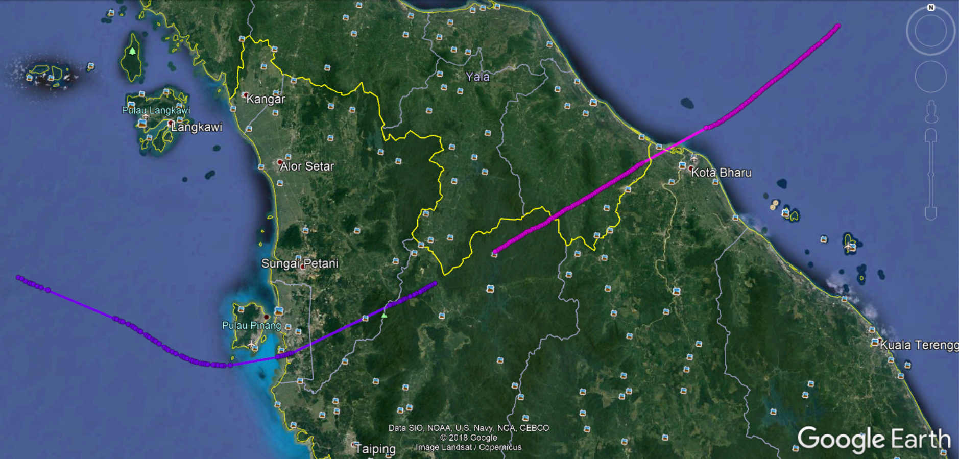
1. Below is the primary surveillance radar data trace, provided by Mike Exner. This plot was derived from a reliable source. The data points show what is thought to be MH370's track after the turn back from IGARI. It crossed the northeastern coast about 5 miles north of Kota Bharu airport and continued in a southwesterly track towards a point 7 miles south of Penang International Airport before turning northwesterly until it was out of primary radar range.
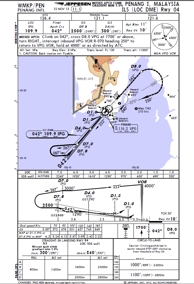
Below is the published STAR or Standard Terminal Arrival chart for aircraft landing on Penang’s runway 04. The arrival procedure that concerns MH370 is the BIDMO 1A arrival which starts at the waypoint BIDMO, and then proceeds to PUKAR and ENDOR.
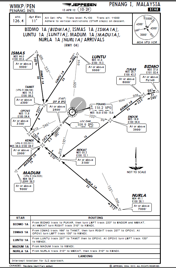
The other point of interest on that arrival chart is the point labelled (FAP) D7.8 IPG. This is the final approach point for aircraft landing on runway 04 using the ILS approach procedure. It is a point in line with the runway at 7.8 miles from IPG which is the touch down point on the runway.
2. Below are the location of the waypoints, BIDMO, PUKAR, ENDOR superimposed on the primary surveillance radar data plot. The latitude/longitude coordinates of these waypoints have been derived from the Jeppesen STAR (Standard Terminal Arrival) chart (see above) current at the time of MH370's disappearance. Jeppesen charts are the industry standard and are used by many airlines operating around the world.
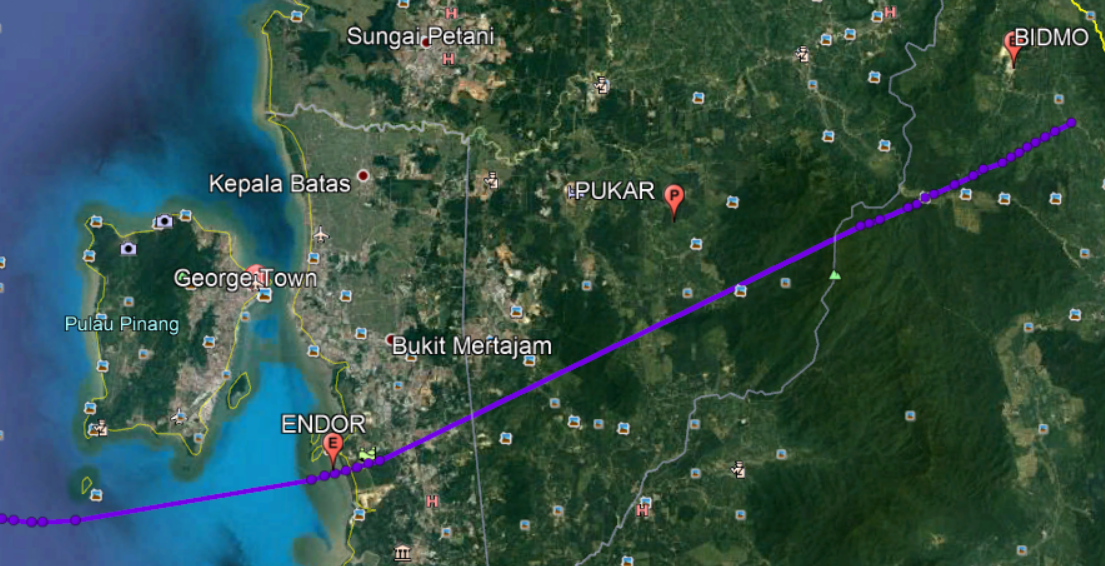
Under normal circumstances, aircraft are usually cleared to arrive at an airport via a Standard Terminal Arrival procedure (STAR) which specifies the route required to be flown via specific waypoints. Standard Terminal Arrival procedures may also specify altitude and airspeed constraints during the arrival. In an emergency pilots may choose, or, air traffic control (ATC) may direct aircraft to not fly the full Standard Terminal Arrival procedure but take short cuts to track directly to waypoints along the arrival route to expedite the arrival and landing. This is also commonly done under normal operations when ATC needs to sequence traffic in busy airspace. The primary surveillance radar plot pictured above suggests that MH370, after turning back from IGARI, may have tracked closely to BIDMO and PUKAR waypoints of the BIDMO 1A Standard Terminal Arrival and passed directly overhead ENDOR.
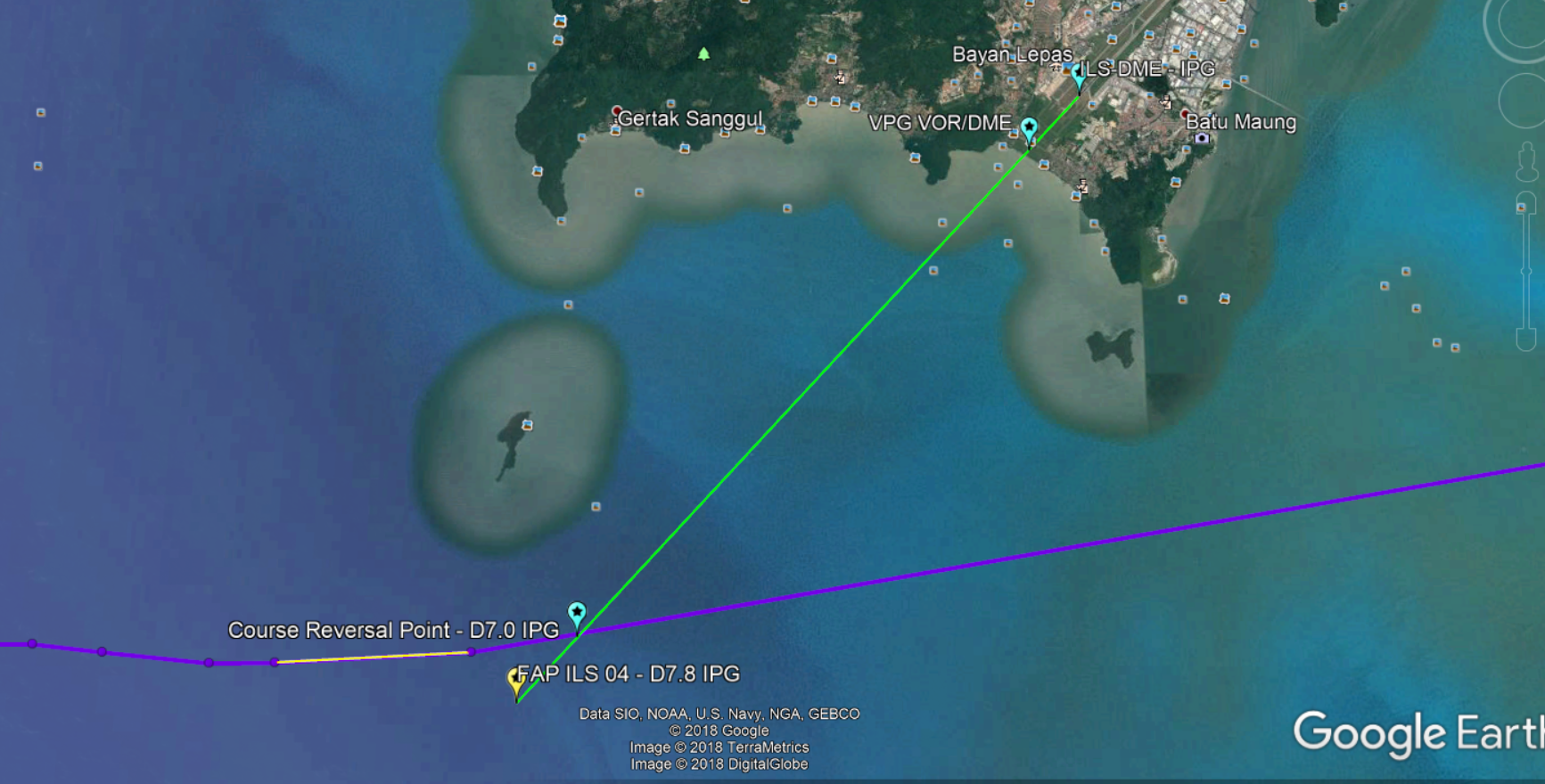
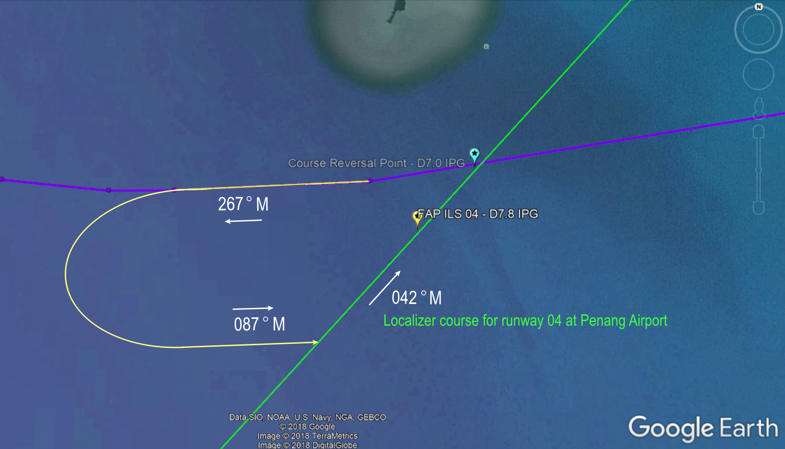
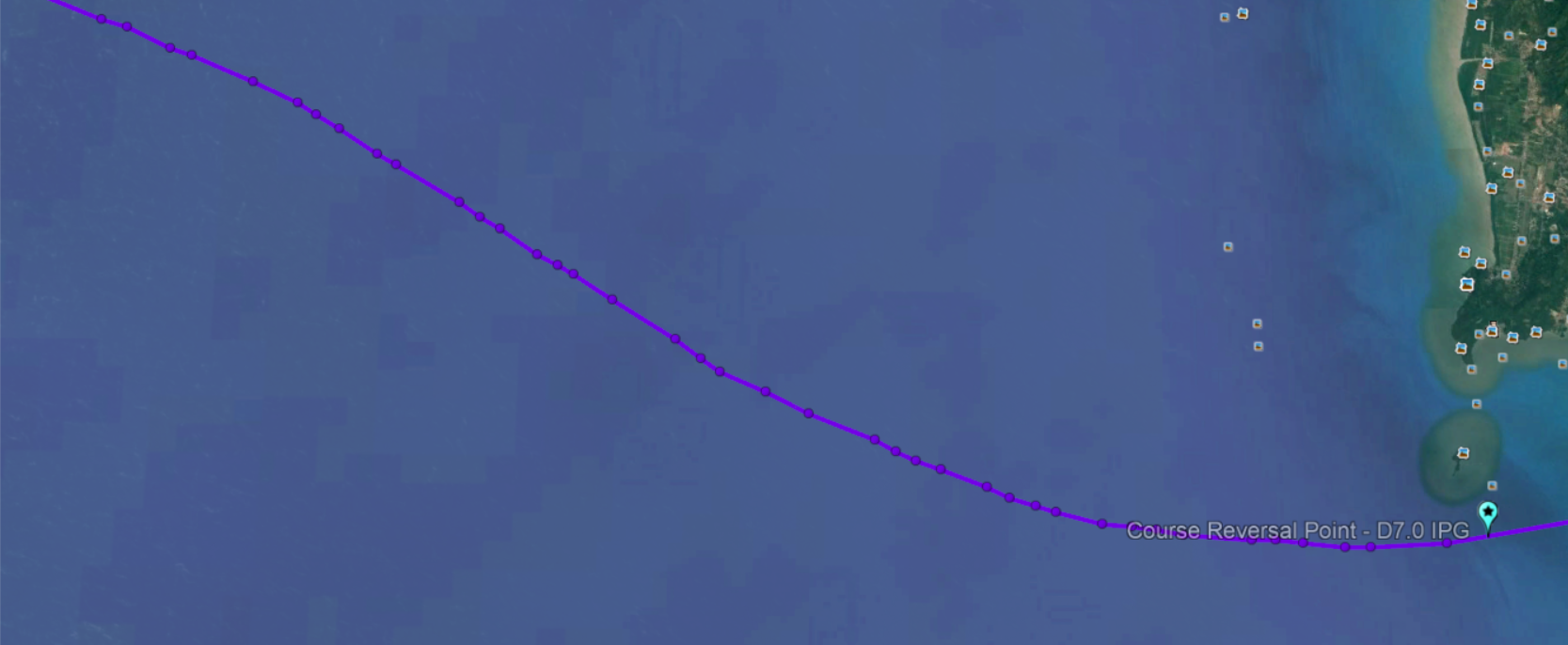
3. From ENDOR, it appears MH370 then tracked directly to a point from which a course reversal procedure can be flown to allow intercept of the final course for runway 04 at Penang Airport. This point for the course reversal procedure is a published point on the Instrument Landing System (ILS) approach chart for Penang’s runway 04. This point is located 7 miles from the touch down point on the runway. On the ILS approach chart, it is labelled D7.0 IPG. The primary surveillance radar data suggests that MH370 may have flown directly overhead this point to commence the course reversal procedure.
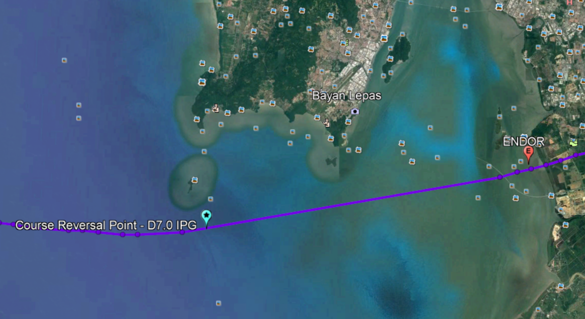
The ILS approach chart for Penang's runway 04 is shown below. The course reversal point is the point labelled D7.0 IPG on the chart. It appears that MH370 flew DIRECTLY OVER this point.
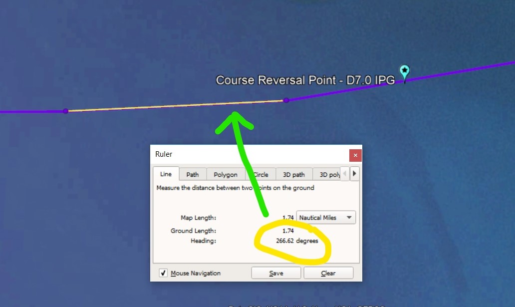
4. After flying over D7.0 IPG, the procedure calls for a track of 267◦ Magnetic to be flown. The primary surveillance radar trace shows a slight turn to a track of 266.62◦ True. Rounding this up gives us 267◦ True. There was zero magnetic variation in Penang in March 2014 so 267◦ T is the same as 267◦ M. From the primary surveillance radar data plot it appears MH370 flew the commencement of the course reversal procedure EXACTLY as published on the ILS approach chart by tracking outbound on a course of 267◦M .
After flying outbound on a track of 267◦ M, to complete the course reversal, MH370 was then required to make a 180◦ turn to the left to track 087 ◦ M and then intercept the localizer to line itself up with the runway. It would then track inbound on the localizer to cross the final approach point at 2500 ft to commence the final approach in to Penang airport's runway 04. (See the diagram of the ILS approach chart above).
This latter part of the course reversal procedure which required MH370 to make a 180◦ turn to the left to track 087 ◦M did not happen and MH370 continued flying on until fuel exhaustion.
5. In summary, 3 definitive events suggests strongly that MH370 diverted to Penang International Airport in an attempt to land on runway 04.
These are;
- MH370 tracked DIRECTLY OVER the waypoint ENDOR on the BIDMO 1A standard arrival procedure.
- MH370 tracked DIRECTLY OVER a point from which a course reversal procedure could be flown to enable it to line up with Penang airport's runway 04. This point is labelled on the approach chart as D7.0 IPG.
- MH370 turned right on a track of 267◦ M to commence the course reversal procedure as it was required to do as published on the instrument approach chart.
Some may argue that these are lucky coincidences that MH370 made these crossing waypoints and tracks. If MH370 passed by these points by a few miles or so, then it may have been just a coincidence, however the primary surveillance radar data plot suggests that MH370 flew DIRECTLY OVER ENDOR, the D7.0 IPG fix and tracked to the degree, the published track for the course reversal procedure. You cannot get any more precise than this. When you consider that the flight back from IGARI towards Penang appears to be hand flown manually without the autopilot engaged, this then demonstrates an example of fine flying skills and airmanship, most likely by Captain Zaharie.
6. Why then didn’t MH370 complete the procedure turn to intercept the localizer for the ILS and complete the approach and landing?
There could be several reasons for this. The lateral tracking, in my opinion, unequivocally shows that MH370 was trying to set itself up for the landing at Penang but may have been at too high of an altitude and too fast an airspeed to conduct the approach. The ground speed of the MH370 at this point is estimated to be approximately 517 knots which also suggests that it was at an altitude above 30,000 ft. I will elaborate more about why this may have been so in subsequent reports.
The fact that MH370 appeared to be flying manually without the use of the autopilot at this point would suggest some kind of systems malfunction had occurred as they were not tracking in LNAV, but from what appears to be very ‘back to basics’ navigation using radio navigational aids and a heading and possibly even combined with visual navigation (the city lights of Penang on a clear night can be seen as far as 100 miles out at altitude). If they had dual FMC failure, then they would not have LNAV available for automatic tracking and sequencing of waypoints and no VNAV available for descent planning which could leave them too high on the descent and approach profile. This might explain also why MH370 did not fly the full STAR tracking to BIDMO, then PUKAR and ENDOR, but flew directly to ENDOR instead.
7. Why would a course reversal procedure be attempted? Why not simply intercept the ILS localizer (final approach course) from the track coming from ENDOR?
Coming from ENDOR, MH370 was on a track of 260◦ T. Magnetic variation = 0, so its magnetic track is also 260◦ M. To intercept the localizer to line up with runway 04 would require a right turn of 142◦. This is incredibly hard to do for any aircraft, let alone a widebody airliner that would be flying at about 200 knots (370 km/hr).
The course reversal procedure has an outbound track of 267◦M, then a 180◦ left hand turn to a track inbound on 087◦ M. This then creates a much easier intercept angle of 45◦ to intercept the localizer for runway 04 which has an inbound course of 042◦ M. Penang has a magnetic variation of 0 degrees (during March 2014) so Magnetic tracks are the same as True.
8. Could the pilots have been incapacitated soon after passing Penang?
The primary surveillance radar plot after passing the course reversal point shows many small track changes over short distances (38 track changes over a space of 33 nautical miles).
This may suggest;
- There was frequent manipulation of the control yoke whereby the aircraft was under intermittent manual control by partially incapacitated pilots.
- The pilots were completely incapacitated and the aircraft may not have been under any positive control by anyone and was left meandering on its own accord at random, possibility resulting in a phugoid flight pattern.
- The aircraft was flying under manual control by someone with no clear direction or destination in mind.
9. I would like to make one last point. The Captain of MH370 was a Boeing 777 TRI/TRE. This means that Captain Zaharie was an instructor on the Boeing 777 as well as a Malaysian Department of Civil Aviation delegated examiner. In this role as a line Captain instructor and examiner, he would have spent many hours in the simulator training other Captains and First Officers for such a scenario where a return to base, or a diversion to a nearest suitable airport in an emergency had to be made as part of pilots’ recurrent training. Training Captains do these kind of training events frequently and I have no doubt that MAS would have used Penang as a diversion aerodrome for such, considering Penang is one of the major airports in Malaysia where the Boeing 777 can operate from. My point here, is that Captain Zaharie in this role would know this airport and the instrument approach procedures very well. If there was any pilot who could pull this suggested scenario off, involving most probably manual flying under abnormal operations with limited cockpit instrumentation and resources, it would have been him. The accuracy of the flying exhibited as shown from the primary radar data plot showed extraordinary precision flying in trying circumstances.
10. Two other key points which I will explore soon in a different report are;
- The possibility that MH370 was flown without the autopilot engaged after turning back from IGARI. If this is true, then this is a huge point to consider because a key assumption of the multi-million dollar search for MH370 in the Southern Indian Ocean was that it flew with at least one of the autopilot modes engaged. As mentioned in this report, the many track changes over short distances that we see from the primary surveillance radar data trace does not resemble the behavior of an aircraft that was flown with the autopilot engaged. It suggests that MH370 was under manual control for the whole time it flew back from IGARI and across Malaysia covering 262 nautical miles until its radar trace was lost. The implication of flight with autopilot disengaged is also highly significant. If a pilot, or anyone who was in control of MH370 contemplated on flying the aircraft for the next 7 hours until fuel exhaustion, they most likely would not be flying the airplane manually with the autopilot disengaged. On the other hand, there are reasons for why a pilot would fly with the autopilot disengaged, with the most likely reason being due to a systems malfunction. More about this in a later report.
- The altitude of flight level that MH370 was flying after the turn back from IGARI. This is another significant consideration as the altitude that the aircraft flew will have implications on the speed, fuel consumption and consequently the time that MH370 can remain flying, that is, it's endurance in the air. Furthermore, not maintaining a consistent altitude during the flight would also suggest some kind of systems malfunction had occurred. It may also suggest that there was limited control input from the pilots possibly due to pilot incapacitation.
KMZ files (to be used with Google Earth) for BIDMO, PUKAR, ENDOR, FAP D7.8 IPG, D7.0 IPG (course reversal point), ILS DME IPG, LOC ILS 04 can be downloaded from here.